Corias - Core Interpretation Assistance - 74, Allee de la Robertsau F-67000 Strasbourg
Phone: +33.3.88.24.24.00 - Mobile: +33.6.07.56.11.78 -
Mail: christian@corias.com
© Corias 2025 - All rights reserved.
Reorientation with seismic map
The original data obtained from the reference line are computed and rotated to their real spatial position by a reorientation process in 3 steps.
The data are first plotted on a stereonet for each non connected reference line respectively.
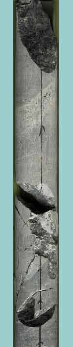
During the data collection, various sedimentary features like bedding, dissolution seams , stylolites etc… are collected as well as all other tectonic features.
The second step consists of reprocessing of all the stereonet in order to find some similiraties and same organization for all collected planes. After this operation, we are looking if clear trends appear for tectonic and sedimentary planes.
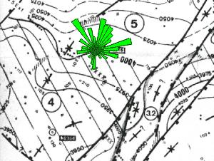
In a third step, all data are reoriented in order to make the trends fit with the geophysical information. The geological trends obtained are subsequently compared to the information from the available geophysical documents, especially the seismic map showing the structural dip at formation level. The sedimentary planes are then rotated until they will be similar to the trends shown on the map.
This reorientation process is done only on well preserved core fragments, to reduce the uncertainty.
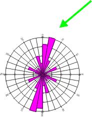
Position of best trend for bedding plane observed on the seismic structural map
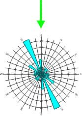
Orientation of tectonic planes and induced fractures after correction from direction deduced from the bedding planes.
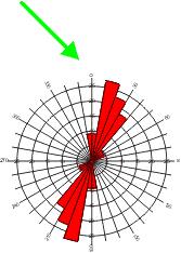
Open Fractures
Cemented Fractures
Induced Fractures